
Grand teton, yellowstone, yosemite, kings canyon, sequoia
13 MAY 2017
The drive to St George was faster than expected. 4 hrs 15 minutes to South Point and lunch at Kahuku Poke. Another 2 hours to St George and Pioneer Park. Pioneer park reminded me of Vasquez Canyon where you can explore unique rock formations by roaming and climbing anywhere you want to. We spent about 45 minutes walking around so we didn't go very far but it was interesting doing a little climbing. We looked for the T bone trail but really couldn't distinguish one trail from another. Steak and burrito at Ricardo’s and the Howard Johnson provided breakfast.
14 MAY 2017 SUNDAY
ST GEORGE TO HEBER CITY, UT
Continued up Highway 15 to Leeds exit 22 to the Red Reef trailhead. What a compact, great campgrounds with lots of hiking trails. The Red Reef trail was about a mile long into a canyon in the Red Cliffs National Conservation area. Beautiful hike along a stream where we were hoping to see desert tortoises or Gila lizards. Had to climb over a large boulder using step holes cut into the boulder and a rope left behind.
Instead of taking Hwy 15 all the way to Provo we took Hwy 70 and 89 hoping for a more scenic route. It started off that way but quickly turned boring and I would not take that longer drive again. Ate at a Costa Vida Mexican Grill, a slightly better Chipotle clone. The scenic byway from Provo to Heber city was pretty but, unfortunately, Bridal Veil Falls trail and other sites we wanted to see were closed due to erosion of trails due to high water runoff. Got to the Holiday Inn Express early and had take out from the very good Back 40 Grill.
I didn't realize we were only 20 minutes from Park City and should've stayed there instead of Heber City.
15 MAY 2017 MONDAY
HEBER CITY, UT TO JACKSON, WY
A third day of mainly just driving from one city to the next. We took Hwy 80 and I89 instead of I15 for a more scenic view. The 5 hour drive was pleasant but I89 had too many small towns and 30 mph speed zones as we approached Jackson. We did see a number of Pronghorn antelope along the southern part of I89. The Hwy straddles the borders between Idaho, Utah and Wyoming so we crossed state lines five times.
The Antler Inn is perfectly located in the center of Jackson town. Lunch at Café Genevieve and a drive through the Elk Refuge took up most of the afternoon. Saw some bighorn sheep in the refuge and had time to check out the Cache Creek camp and trail area. Took the Putt Putt trail and found a deer carcass so I turned back not wanting to find what killed it. Also walked about a mile on the river trail which was only okay.
Went on an evening wildlife tour with Ecotours with some folks from Florida and Kansas City and tour guides Chelsea and Mariah. Trisha from Rover.com met us at the hotel and watched Daisy while we went in search of bears and wolves. The tour was average although we did see a lot of elk. Also saw some bison and mule deer but no predators. I was expecting to access private land or some off roading but we stayed on public streets off the main Hwy 191. For next trip, we explored Antelope Flats, Schwabacher Landing, and Moose Wilson roads. I didn't feel they provided any service worth the $130 cost per person.
Learned that Aspens are brittle trees that can just snap in high winds that accounted for the large number of broken trees that we saw.
16 MAY 2017 TUESDAY
GRAND TETON NATIONAL PARK
There are two roads that run parallel from Jackson to get to the Grand Teton visitors center. We decided to re-track last night’s trip and went up Moose Wilson road through the Laurence S Rockefeller reserve. We weren't rewarded with wildlife sightings.
From the visitors center in the city of Moose there are also two parallel roads that run through the national park, Hwy 191 or Teton Park Road. The visitor center recommended Teton Park Road so off we went. The road runs close to the Grand Teton range where the Grand Teton is also the name of its tallest peak. The Jenny Lake Road gave us the opportunity to get a photo of the Grand Teton peak and its mirror reflection in the lake.
YELLOWSTONE NATIONAL PARK
The park road joins with Hwy 191 near Oxbow Bend which was one of the prettiest spots we have seen. Hwy 191 took us to the south entrance of Yellowstone that luckily just opened 4 days earlier. Lots of plowed snow lined the main park roads. Many of the parks side roads are still closed for winter including Grant Village at the south end of the figure eight roads. We headed directly to Old Faithful so we could see the eruption before tomorrow's storm. We arrived in the parking lot just in time to see spray over the visitor centers roof so we had to wait another 90 minutes for the next eruption. Old Faithful isn't the largest geyser but it's the easiest to see due to its predictable regularity. The Old Faithful Inn is an amazing piece of architecture. Incredible interior balconies were the inspiration for Disneyworld’s Wilderness Lodge.
Next was the Midway Geyser Basin which reminded me a lot of the Waimangu and Waiotapu thermal pools in New Zealand. The basin had many colorful, steaming, bubbling thermal pools and even some small geysers. Also stopped by the Lower geyser basin and the Fountain Paint pot pool. Wasn't quite as inspiring as the Midway Basin. Further north before the intersection at Madison, we took the Firehole Canyon Drive that took us past the Firehole waterfall. It was getting late and we still had over an hour to get to Gardiner, MT so we got back on the road, however, Gibbon Falls and Norris Geyser Basin distracted us along the way. Gibbon Falls was a fast, high volume falls and Norris basin is the home of Steamboat geyser, the largest in the world with eruptions up to 300 feet high.
It seemed ironic that we spent so much effort to see wildlife over the last many days but we had the closest encounter with elk and bison while driving through the town of Mammoth Hot Springs. Just tens of feet from the road and on the lawn of the post office were a half dozen elk and as many bison with four calves in tow. Amazing.
Gardiner is 6 miles past Mammoth Hot Springs but down several thousand feet into a canyon and outside the park in another state, Montana. Would not stay here again. The northwestern quadrant of Yellowstone probably has the least to see and not worth spending the night on that side. Better to stick with West Yellowstone as a base of operations. The Best Western Mammoth Hot Springs is situated right on the Yellowstone River and we have a spectacular view of the park mountains and the river. BBQ from a local market.
Factoid: We crossed the continental divide 3 times going north from the south entrance. The continental divide is defined as the separation of hydrological watersheds (rivers) that drains to the Pacific and the Atlantic.
17 MAY 2017 WEDNESDAY
YELLOWSTONE NP
Finding out that more Yellowstone roads are closed. The entire eastern roads from Tower-Roosevelt to Canyon to Lake were closed and other sight seeing areas like Inspiration, Grandview, and Uncle Toms Points are closed due to construction.
Today was a snowy day that stayed in the 20s. A little worried about climbing the mountain from Gardiner but the roads were fine. Mammoth Hot Springs has an incredible network of wooden boardwalks that traverse the many travertine terraces and thermal areas. We walked to Liberty Cap and Palette Springs and drove the upper terrace loop.
On the road to Norris, we encountered a cub and mother black bear. They were foraging and oblivious to all the cars pulling over. Also came across four bison blocking the road. They refused to move off the center stripe until a Yellowstone van nudged them over. One walked along side our car and was less than three feet from Karen's camera when it grunted at Daisy. From Norris we travelled east to Canyon Village to see how far we could get. Roads weren't bad until the final two miles from the village where they became very slushy. It was still snowing pretty hard and I started sliding when braking and accelerating so we didn't stay long at the Visitor Education Center. Saw more bison walking on the side of the road.
Today we stopped at a few thermal areas that we missed yesterday. The Artists paintpot was a nice half mile trail that was beautiful covered in snow. Stopped at the Midway Basin again to get a better view of the Grand Prismatic Spring. Today's wind conditions afforded a slightly better view of the colors than yesterday. Then stopped at the Black Sand Basin and Kepler Cascades. Normal road closures were bad enough but today's weather also shut down the south part of the park at Kepler Cascades. Feeling defeated, we decided to waste a little time at Old Faithful again. This time we timed our arrival perfectly and waited only 10 minutes before the next eruption. Decided to head to West Yellowstone early and get some rest. Saw lots more bison on and near the roadway.
West Yellowstone is a pretty big town. We stayed at the Pony Express because all other dog friendly hotels were booked. The room was clean and updated with a CRT TV. Pizza and Chicken Parm at Petes Rocky Mountain.
18 MAY 2017 THURSDAY
YELLOWSTONE NP TO TWIN FALLS, ID
Well, it was a day of surprises. With so many road closures, we decided to leave Yellowstone today instead of tomorrow. We planned to visit Lamar Valley in the morning, then drive to Twin Falls in the afternoon but the road from Norris to Mammoth in the park had been closed since yesterday and was not open this morning.
We woke up to see the car covered by 2 inches of snow and the road looking rather icy and light snow still coming down. I assessed the probability of the road closure being lifted as slim so we decided on a relaxing day driving to Twin Falls. Worried a little about getting through the Targee Pass but the lady at the lobby allayed my fears.
As we left the city, we saw a billboard for Yellowstone Bear World that sounded interesting so made a point to stop by 75 miles south on Hwy 20. It was a surprisingly fun stop. It was a mini wild animal park where you drove yourself and viewed animals in a relatively free range environment. We were warned not to stop because bears would climb on your car. We saw elk, bison, deer, Rocky Mountain goats, Moose, and lots of black and grizzly bears. And I do mean lots of bears, over 40 by their count. The highlight however was seeing 6 four month old bear cubs that were incredibly adorable playing with each other and being fed. Such a neat experience and we were lucky that they just opened for the season the past weekend.
The rest of the trip to Twin Falls had continually improving weather and higher temperatures and it ended up being a sunny, gorgeous day. Just before Twin Falls we followed the signs to Shoshone Falls, not really knowing what to expect. Well it was the second most spectacular waterfall I have ever seen behind Niagara Falls. In fact, it is called the Niagara Falls of the west. Not as tall and not as big a horseshoe but equal water flow and more layers of falls. Similar spray due to height and amount of water drop and similar rainbow effects. I was really surprised and in awe at such a stumble on stop. A nearby trail took you to some lookouts and supposedly to the site where Evel Knieval tried rocketing over the Snake River. Didn't make it that far but the lookouts were great.
Entering Twin Falls we headed to the Perrine Bridge and visitors center. The bridge is approximately a 1000 foot span and 500 feet above the Snake river and is the eighth highest bridge in the US. Coincidentally, we could see the site of Evel Knieval’s attempt from the bridge. As we were leaving, we saw a group of people prepping to parachute from the bridge. They called it base jumping but we witnessed a half dozen parachuters jumping from the center of the bridge. Very lucky timing on our part.
The Best Western Twin Falls is one of the nicer hotels and we are ate at a Costa Vida Mexican Grill again.
19 MAY 2017 FRIDAY
TWIN FALLS, ID TO TONOPAH, NV
A long and boring drive today. Long stretches of straight desert roads and nothing interesting to see. 7 hours total through very desolate areas where we were the only car within miles for long stretches of distance. Funny to see a white car with racing stripes get pulled over by Nevada police twice, likely by the same patrol man. Got a little worried about gas during the last 100 mile stretch before Tonopah but luckily found a gas station near Round Mountain.
Tonopah has an interesting history being the center of a silver rush in 1900. Tono meaning brush and Pah meaning water, the city was named for the brush and springs nearby. James Butler allegedly discovered silver ore while looking for his lost mules in 1898. He and wife Belle staked claim to the richest silver mine areas. The Tonopah Mining Park still has remnants from their old mining operation and celebrates Butler Days around Memorial weekend every year.
The Tonopah Station and Casino is actually a neat place to stay. Very low cost, updated, large rooms, and old west décor. Reminds me of Ruby’s Inn at Bryce. I liked the old west pictures in the rooms and the large Mona Lisa portrait in the main stairway. Brisket for dinner at Tonopah Brewing Company.
20 MAY 2017 SATURDAY
MAMMOTH LAKES
Today was our lazy day. Only a two and a half hour drive and nothing to do because all the roads are closed. We wanted to drive as far as we could knowing the roads to Devils Postpile and Lake Mary were closed. The end of the roads had no barricade or signs, it just ends at 10 foot snow drifts. The ranger at the visitors center told us about Mammoth Creek trailhead where the 203 and 395 meet. We followed the creek for about a half mile. The waitress at Mammoth Brewing Co told us about Shady Rest park and its forested trails that we also walked before checking in at Motel6.
21 MAY 2017 SUNDAY
MONITOR PASS AND YOSEMITE
OMG, 11+ hours of driving with only one 30 minute stop at O’Shaughnessy’s dam in Hetch Hetchy. Would have liked to have crossed the Sonora Pass but it didn't open as rumored by the MammothTimes. The Monitor Pass, Hwy 89, did not save much time but was a very pretty drive except it had a few uncomfortably acrophobic, too close to the cliff, only seeing blue sky curves. However, the Acura Nav failed me big time by routing me on Hwy 50 instead of Hwy 88 and sent me on a much longer route down to Sonora. Along the way, we passed through Calaveras which was celebrating the Jumping Frog Jubilee! and passed a marker for Mark Twain’s cabin. “Frogtown” was crowded and the city was decorated with clotheslines across the streets.
We reached Yosemite’s Big Oak Flat entrance in little over seven hours. We back tracked a mile to Hetch Hetchy road to take a look at the reservoir. The HH canyon is a large, granite valley with less vegetation than I would have expected. The O’Shaughnessy dam is massive and beautiful. We walked across it and through a tunnel on the far side of the dam that leads to a trail to Wapama Falls.
Historically, Hetch Hetchy Valley was once a beautiful twin to Yosemite Valley. It was dammed in 1923 in response to the 1906 San Francisco earthquake to provide water to SF despite arguments against it from John Muir himself.
On the way to Mariposa through the park on Big Oak Flat road, we stopped at Cascade Falls turnout and a distant half dome lookout. The Merced River is beautiful with its raging white water along Hwy 140.
Dinner at Happy Burger diner was very good. The chicken ranch wrap and chicken fried steak were delicious.
22 MAY 2017 MONDAY
YOSEMITE
Got an early start so we could drop Daisy off at Clouds Rest Pet Care, make the 75 minute drive, and still get to the park early enough to find parking. We were fearful of the horror stories about the traffic and 3 hour delays the day before. Despite arriving at the Arch Rock entrance at 8:45, there was still a half mile line to get into the park.
We decided to park the car and use the park shuttle to get around. Only the green line runs in the spring so not all the valley stops were available by shuttle. First stop at Vernal Falls where we were told that the hike to the bridge was easy. Not so. The .6 mile trail was uphill the whole way but the bridge view of the falls were worth it. Falls were spectacular enough that we decided to take the next .9 miles up to the top. The trail was not as steep as the first half but the last 200 yards were rock steps in the heavy mist of the falls. Guess that's why it's called the Mist Trail. Karen was prepared with a rain jacket while Byron scoffed at the elements.
The park shuttle was now overcrowded making me wonder if driving wasn't better. Had lunch at the Village Market and headed to Lower Yosemite Falls. A short walk took us to the base of the falls and more mist. It's an incredible double falls with a few mini falls in the middle. No more shuttles and the roads didn't look so bad so we decided to drive the rest of the day.
Pulled over at the El Capitan stop to watch a few climbers on the mountain. Then a short walk to Bridal Veil Falls and a lot more mist. Byron still didn't come prepared.
All the falls were spectacular but we were able to get the closest to Vernal Falls and the longer trail and unusual rock steps made it my favorite.
Left the park around 4 pm after watching a few more climbers on El Capitan. Always good to hear that Daisy behaved herself and Trish at CRPC seems like such an interesting and nice person.
Noticed a lot of butterflies buzzing my windshield to find out that we’re in a butterfly migration area. Mariposa is the Spanish name for butterfly and just celebrated the butterfly festival the first weekend in May.
Noticed a lot of dead ponderosa pine trees in the park. The drought weakened a lot of trees and made them susceptible to bark beetles.
23 MAY 2017 TUESDAY
YOSEMITE AND BASS LAKE
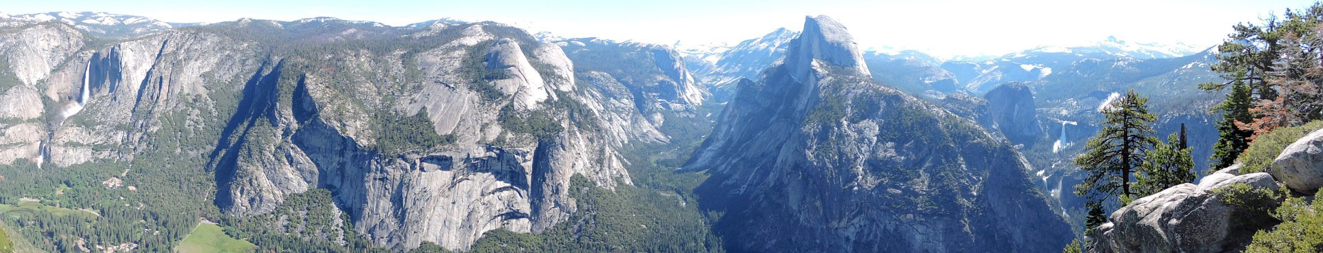
Today was planned as another leisure day exploring the southern part of the park and primarily Glacier Point and Wawona meadows. The road to Glacier Point was 32 winding miles out of our way and I was just grumbling how no view would be worth the drive when we came to Washburn Point and I was proven wrong. Spectacular overlook of Yosemite Valley where you can see Half Dome, Vernal, Nevada, and Illilouette Falls in one snapshot.
Another couple of miles further was Glacier Point with an equally spectacular view of Half Dome and Yosemite Falls. Glacier Point is also a trailhead for many hikes and had a Visitor Center. The rest of the drive past Wawona Meadows was uneventful.
Arrived at Bass Lake, had lunch at Ducey’s, where Blake and Gwen ate earlier in the month, and rented a pontoon/patio boat for a couple of hours to cruise the lake and bide time until check in at The Pines Resort. Other than the $75 pet fee, the chalet was reasonable and was a rustic, remodeled, three floor cabin. Situated in a woodsy area, on a hill, surrounded by trees, with a large deck, it is a great place to stay. Today was sunny and pleasant but it did hit low nineties in Bass Lake.
Found out many restaurants are closed and only open for summer so the Pines Bakery and Pizza plan turned out to be frozen pizza at the market.
24 MAY 2017 WEDNESDAY
KINGS CANYON AND SEQUOIA NP
Decided to backtrack a few miles and take Hwy 41 into down to Fresno and onto hwy 180 into Kings Canyon. Passed by Squaw Valley that was celebrating Turkey Testicals Festival next month. The drive into the canyon reminded me of Hetch Hetchy but longer, steeper, and scarier. It was 35 miles from the Generals highway and 13 miles of it seemed like a constant 7% grade hugging 1000+ foot winding cliffs.
While the Yosemite River was raging whitewater, the King River was a violent, frothy, angry river creating waterfall type spray just from the churn. Once we got down to the valley floor, the violence of the river looked like it could jump the river banks at ant time. Beautiful Roaring Creek Falls and Grizzly Falls were near the end of the scenic byway. It took us two and half hours into the canyon that included stops to General Grants tree, second largest in the world by volume, and lunch at the Cedar Grove Village but it only took an hour to get back. The Kings Canyon Road actually starts in Kings Canyon NP, enters Sequoia National Forest, and ends up back in the NP.
The journey through Sequoia NP on Hwy 198 actually starts in Sequoia National Monument, then through Sequoia National Forest, then into the National Park. First stop at General Shermans Tree in the Giant Forest, the largest in the world by volume. Lots of Giant Sequoias surround Shermans Tree, they are so amazing. Further down the road we find the tunnel tree where you drive inside a giant sequoia, too bad its dead and lying on the ground. Nearby is Moro Rock but I'm too tired to climb the 300 steps to the top of the rock. Further down the highway, you continue to pass more Giant Sequoias adjacent to the road. You can't help but be amazed the the girth of their trunks. Crystal Caves is scheduled to open this coming weekend so we have to pass on it.
As we near the southern end of the park and think you're finished with the park, you encounter the most winding part of the road where it tortures you with what seems like a hundred 10 mph hairpin turns. Exhausted, we finally arrive at Three Rivers and the Lazy J Ranch. Very quaint cottages near the Kaweah river and its own wilderness is more unique than Motel6 or Best Westerns. A light dinner at Sierra Subs and Salad was a perfect close to a momentous, tiring, driving day.
25 MAY 2017 THURSDAY
SUMMARY
Middle of May is still a good time to visit the National Parks and avoid hot weather and large crowds on a typical year. This year, with the record snow delayed the opening of roads and therefore access to some sights. Yosemite and Yellowstone are very different parks. Yellowstone is really about wildlife and geysers and thermal pools. Yosemite is geological beauty but little wildlife. Grand Teton is all about wildlife. Kings Canyon and Sequoia don't have many iconic sights like the previous parks but are still pretty to drive through but takes more patience due to the more mountainous roads.
Would like to revisit Yellowstone when the northern and eastern roads are open to see Lamar Valley and the Grand Canyon of Yellowstone but would avoid the more famous geysers on the south western part of the park.
Felt like we saw everything at Yosemite but would be interesting to come back in winter.
MADE WITH ![]() BY MUSEFREE.COM
BY MUSEFREE.COM